
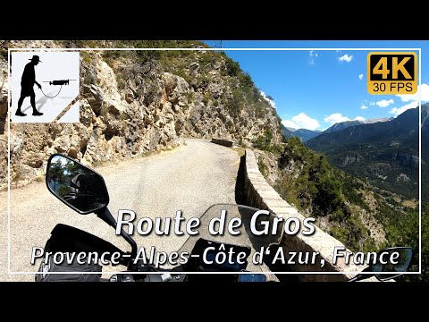
The D37L road, which links the village of Eygliers with the hamlet of Gros, is around 5 km long and is one of France’s scenic balcony raods (Route de Vertige).
The road begins in the village of Eygliers, which lies north of the Vauban fortress of Mont-Dauphin and the small town of Guillestre. It runs from west to east along the northern side of the Guil River gorge (Gorges du Guil). Mont Dauphin, Guillestre, the confluence of the Guil and Durance rivers, and the ski resort of Risoul on the other side of the valley are almost always clearly visible from the road.
The valley of the River Guil forms the southern boundary of the Écrins massif to the north-west and is part of the Queyras region.
The road is tarmac-surfaced throughout but is in a rather poor condition. Much of the road has been carved directly out of the rock and is often very narrow. However, oncoming traffic is not usually a problem, as there are a few passing places. Due to the possibility of snow and ice, this route should only be planned between May and October.
The road is located in the Hautes-Alpes department, within the Provence-Alpes-Côte d’Azur region.
▬ Content ▬▬▬▬▬▬▬▬▬▬▬▬▬▬▬▬
00:00 Intro
00:15 Prolog
01:22 The Ride – There…
09:44 The Ride – …and Back Again
17:56 And the Mavic spoke…
21:56 Outro
▬ Links ▬▬▬▬▬▬▬▬▬▬▬▬▬▬▬▬▬
Playlist France: https://www.youtube.com/playlist?list=PLTYKWgwieoeK4dDbNJy2hHub-Z9y8Fz89
Playlist Passes: https://www.youtube.com/playlist?list=PLTYKWgwieoeK6AgzgiS20gB7sWXHpboC_
WalkTheMavic: https://www.youtube.com/channel/UCVKby-_mUxgoSbw19i30v6Q
▬ About this channel ▬▬▬▬▬▬▬▬▬▬▬▬
Walk The Mavic (WTM) – Interesting roads, passes and gorges in the Alps – Nature and landscapes – Castles, forts, fortresses and fortifications – Photos and videos, if possible and allowed, also aerial photos/videos with the drone.