
To the west of Lake Garda, on the western shore of Lake Idro, lies the small Italian village of Anfo at an altitude of 392 metres. This is the starting point of an old military road which, after a total of around 21 km, leads up to the Giogo del Maniva (1,674 metres) to the north-west.
The road is known as the ‘Dosso-Alto High Road’ and, from the Giogo del Maniva, continues northwards via the ‘Strada Tre Valli’ to the Passo Croce Domini.
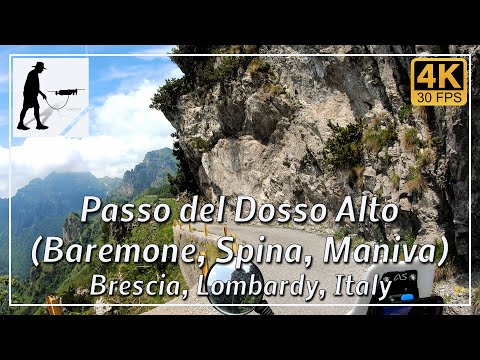
The narrow, winding road initially leads through wooded areas until, after about 11 km, the Passo del Baremone (1,406 metres) is reached, where the Rifugio Rosa di Baremone mountain hut is located. The route continues to the Passo della Spina, where there are also several tunnels. Up to this point, the road is narrow and in rather poor condition, but the surface is tarmac. From here, however, there is a section of around 1.5 km that is only gravel. Now asphalted again, the narrow, partly poor-quality road leads to the Passo del Dosso Alto, which, at 1,715 metres, is the highest point of the crossing. From there, the route descends gently to the Giogo del Maniva.
The road is normally open to public traffic from June to October. However, adverse weather conditions may also lead to closures. The route is popular with cyclists and, in the upper section, with hikers too.
The road is located in the Italian province of Brescia in the Lombardy region.
▬ Content ▬▬▬▬▬▬▬▬▬▬▬▬▬▬▬▬
00:00 Intro
00:15 Prolog
01:32 The Ride
35:26 And the Mavic spoke
39:26 Outro
▬ Links ▬▬▬▬▬▬▬▬▬▬▬▬▬▬▬▬▬
Playlist Italy: https://www.youtube.com/playlist?list=PLTYKWgwieoeK_DKMf6p7uRpSJtF_kd7G5
Playlist Passes: https://www.youtube.com/playlist?list=PLTYKWgwieoeK6AgzgiS20gB7sWXHpboC_
WalkTheMavic: https://www.youtube.com/channel/UCVKby-_mUxgoSbw19i30v6Q
▬ About this channel ▬▬▬▬▬▬▬▬▬▬▬▬
Walk The Mavic (WTM) – Interesting roads, passes and gorges in the Alps – Nature and landscapes – Castles, forts, fortresses and fortifications – Photos and videos, if possible and allowed, also aerial photos/videos with the drone.