
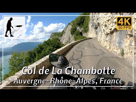
North of the town of Aix-les-Bains, Lake Bourget is bordered to the east by a mountain ridge (Massif de La Chambotte) that still belongs to the French Jura. At the town of Chindrieux at the northern end of the lake, the D991B road begins, which can be used to cross this mountain ridge. The ascent is just under 5 km long and, when the vegetation allows, offers a view of the lake.
At the pass crossing at an altitude of approx. 650 meters, you will find the village of La Chambotte. From here, a small dead-end road branches off to the Belvédère de La Chambotte viewpoint, which offers an impressive view over the lake.
Although there are a few narrow sections and a tunnel, the route is easy to drive overall.
The road is located in the department of Savoie in the Auvergne-Rhône-Alpes region.
▬ Content ▬▬▬▬▬▬▬▬▬▬▬▬▬▬▬▬
00:00 Intro
00:15 Prolog
01:22 The Ride
08:12 Outro
▬ Links ▬▬▬▬▬▬▬▬▬▬▬▬▬▬▬▬▬
Playlist France: https://www.youtube.com/playlist?list=PLTYKWgwieoeK4dDbNJy2hHub-Z9y8Fz89
Playlist Passes: https://www.youtube.com/playlist?list=PLTYKWgwieoeK6AgzgiS20gB7sWXHpboC_
WalkTheMavic: https://www.youtube.com/channel/UCVKby-_mUxgoSbw19i30v6Q
▬ About this channel ▬▬▬▬▬▬▬▬▬▬▬▬
Walk The Mavic (WTM) – Interesting roads, passes and gorges in the Alps – Nature and landscapes – Castles, forts, fortresses and fortifications – Photos and videos, if possible and allowed, also aerial photos/videos with the drone.