
Description
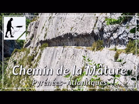
The valley of the river Aspe and its surroundings were rich in trees that were to be used for shipbuilding for the French navy. An area with good tree cover was located to the east above the village of Etsaut / Urdos. Since it was not possible to transport the trees over the Col d'Aras or through the narrow gorge of the river Le Sescoué, it was decided to cut a path in the rock face, on which the tree trunks could be pulled down to the river Gave d'Aspe by draught animals. In 1772, under the reign of King Louis XV, this project was completed and then served as a transport route for about 6 years.
This transport route is known today as the "Chemin de la Mâture". The particularly spectacular section above the gorge of the river "Le Sescoué" is about 900 metres long and lies about 200 metres above the valley floor. The "Chemin de la Mâture" is part of the GR10 long-distance hiking trail.
The trail is located in the western Pyrenees in the department of Pyrénées-Atlantiques and there in the region of Nouvelle-Aquitaine.
▬ Content ▬▬▬▬▬▬▬▬▬▬▬▬▬▬▬▬
00:00 Intro
00:11 Prolog
01:06 The Walk
06:33 Outro
▬ Links ▬▬▬▬▬▬▬▬▬▬▬▬▬▬▬▬▬
Playlist France: https://www.youtube.com/playlist?list=PLTYKWgwieoeK4dDbNJy2hHub-Z9y8Fz89
Playlist Passes: https://www.youtube.com/playlist?list=PLTYKWgwieoeK6AgzgiS20gB7sWXHpboC_
WalkTheMavic: https://www.youtube.com/channel/UCVKby-_mUxgoSbw19i30v6Q
▬ About this channel ▬▬▬▬▬▬▬▬▬▬▬▬
Walk The Mavic (WTM) – Interesting roads, passes and gorges in the Alps – Nature and landscapes – Castles, forts, fortresses and fortifications – Photos and videos, if possible and allowed, also aerial photos/videos with the drone.