
Description
The Splügen Pass, at an altitude of 2,114 meters, is a border pass between Italy in the south and Switzerland in the north. It connects the Italian town of Chiavenna in the province of Sondrio in the Lombardy region with the Swiss valley town of Splügen in the municipality of Viamala in the canton of Graubünden.
In addition to the border between two countries, the pass also forms the border between the geographical areas of the Western Alps and the Eastern Alps.
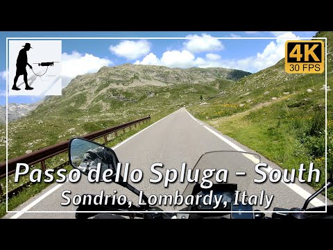
The southern ascent to the pass begins in the Italian town of Chiavenna and is about 30 km long. It involves climbing almost 1,800 meters in altitude. As most of the difference in altitude is covered during the first half of the route, this section includes some steep sections, narrow hairpin bends, and tunnels. However, the road is well constructed overall.
The northern ascent to the pass begins in the Swiss town of Splügen and is about 9 km long. It involves climbing about 650 meters in altitude. The road is well constructed and easy to drive on overall.
The pass is usually closed from November to May. The exact period is adjusted to the prevailing weather conditions.
The road is located in the Italian province of Sondrio in the Lombardy region.
▬ Content ▬▬▬▬▬▬▬▬▬▬▬▬▬▬▬▬
00:00 Intro
00:15 Prolog
01:32 The Ride
22:58 And the Mavic spoke
26:58 Outro
▬ Links ▬▬▬▬▬▬▬▬▬▬▬▬▬▬▬▬▬
Playlist Italy: https://www.youtube.com/playlist?list=PLTYKWgwieoeK_DKMf6p7uRpSJtF_kd7G5
Playlist Passes: https://www.youtube.com/playlist?list=PLTYKWgwieoeK6AgzgiS20gB7sWXHpboC_
WalkTheMavic: https://www.youtube.com/channel/UCVKby-_mUxgoSbw19i30v6Q
▬ About this channel ▬▬▬▬▬▬▬▬▬▬▬▬
Walk The Mavic (WTM) – Interesting roads, passes and gorges in the Alps – Nature and landscapes – Castles, forts, fortresses and fortifications – Photos and videos, if possible and allowed, also aerial photos/videos with the drone.