
Description
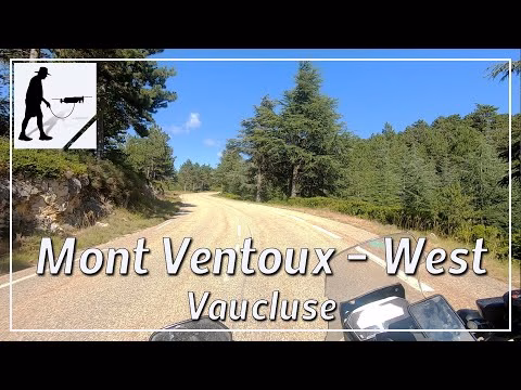
The western ascent to the summit of Mont Ventoux begins in Malaucène and leads on a well-maintained road after about 20 km to the finish at about 1900 meters above sea level. The road is easy to drive on. Parts of the road, especially in the upper third, were resurfaced because of the Tour de France, which took place there in 2021. Since the road is rather on the more protected west or north side of the mountain, it leads mostly through wooded areas except for the last few kilometers. Nevertheless, you will often find places with an impressive view. Only in the last kilometers does the road, which is still in good condition, pass through rock and gravel fields. This road (not only the west but also the east ascent) makes the mountain a popular destination and it is a challenge for every amateur cyclist. On the summit there are several transmitting stations and an observatory. In good weather, you can see the Mediterranean Sea from the mountain. The mountain is located in the Pre-Alps of Provence and there in the department of Vaucluse.
▬ Content ▬▬▬▬▬▬▬▬▬▬▬▬▬▬▬▬
00:00 Intro
00:15 Prolog
01:02 The Ride
20:44 Outro
▬ Links ▬▬▬▬▬▬▬▬▬▬▬▬▬▬▬▬▬
Playlist France: https://www.youtube.com/playlist?list=PLTYKWgwieoeK4dDbNJy2hHub-Z9y8Fz89
Playlist Passes: https://www.youtube.com/playlist?list=PLTYKWgwieoeK6AgzgiS20gB7sWXHpboC_
WalkTheMavic: https://www.youtube.com/channel/UCVKby-_mUxgoSbw19i30v6Q
▬ About this channel ▬▬▬▬▬▬▬▬▬▬▬▬
Walk The Mavic (WTM) – Interesting roads, passes and gorges in the Alps – Nature and landscapes – Castles, forts, fortresses and fortifications – Photos and videos, if possible and allowed, also aerial photos/videos with the drone.