
Description
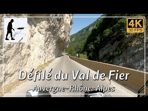
The northern end of the Chamotte massif is cut through by a gorge at Seyssel / Châteaufort, carved into the rock by the River Fier. The gorge is about 5 kilometres long and runs exactly from east to west. The D14 road also runs parallel to the river and always above it on its north side. Apart from a short narrow section, the road is two-lane, very well constructed and easy to drive on. There are two tunnels along the western section of the route, followed by a narrow section controlled by traffic lights. Here you drive past or under a fairly high rock face. The road connects to the main road D991 between Seyssel and Châteaufort in the west and the village of Saint-André in the east. Part of the course of the river forms the border between the departments of Savoie and Haute-Savoie. The road itself is always in the department of Haute-Savoie and there in the province of Auvergne-Rhône-Alpes.
This stretch is one of the so-called "French Balcony Roads".
▬ Content ▬▬▬▬▬▬▬▬▬▬▬▬▬▬▬▬
00:00 Intro
00:15 Prolog
01:11 The Ride – There…
07:28 The Ride – …and Back Again
13:19 Outro
▬ Links ▬▬▬▬▬▬▬▬▬▬▬▬▬▬▬▬▬
Playlist France: https://www.youtube.com/playlist?list=PLTYKWgwieoeK4dDbNJy2hHub-Z9y8Fz89
Playlist Gorges: https://www.youtube.com/playlist?list=PLTYKWgwieoeJHap1bKTsn_Pcjo8_V89rP
WalkTheMavic: https://www.youtube.com/channel/UCVKby-_mUxgoSbw19i30v6Q
▬ About this channel ▬▬▬▬▬▬▬▬▬▬▬▬
Walk The Mavic (WTM) – Interesting roads, passes and gorges in the Alps – Nature and landscapes – Castles, forts, fortresses and fortifications – Photos and videos, if possible and allowed, also aerial photos/videos with the drone.