
Description
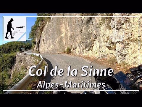
The M59 road runs in an east-west direction and connects the Gorges du Cians in the west with the Gorges de la Tinée in the east. The road is about 26 km long in total; the eastern ascent to the Col de la Sinne is about 14 km long. To the west, the road branches off the main D28 road at Pra d'Astier; to the east, it branches off the M2205 road just north of the village of La Bollinette. The western ascent to the Col de la Sinne leads through the village of Pierlas; the eastern ascent leads through the village of Ilonse, among others. The eastern ascent shown here is quite steep and narrow at the beginning and leads up the mountain in several serpentines. Then the landscape widens and the road is no longer quite so narrow. From the village of Ilonse, the road becomes narrower again and, after another 4 km, leads to the 1440-metre high pass. The western descent then also leads through some wooded areas as far as Pierlas. The road lies in the province of Provence-Alpes-Côte d'Azur and there in the department of Alpes-Maritimes / Maritime Alps.
▬ Content ▬▬▬▬▬▬▬▬▬▬▬▬▬▬▬▬
00:00 Intro
00:15 Prolog
01:15 The Ride
22:42 Outro
▬ Links ▬▬▬▬▬▬▬▬▬▬▬▬▬▬▬▬▬
Playlist France: https://www.youtube.com/playlist?list=PLTYKWgwieoeK4dDbNJy2hHub-Z9y8Fz89
Playlist Passes: https://www.youtube.com/playlist?list=PLTYKWgwieoeK6AgzgiS20gB7sWXHpboC_
WalkTheMavic: https://www.youtube.com/channel/UCVKby-_mUxgoSbw19i30v6Q
▬ About this channel ▬▬▬▬▬▬▬▬▬▬▬▬
Walk The Mavic (WTM) – Interesting roads, passes and gorges in the Alps – Nature and landscapes – Castles, forts, fortresses and fortifications – Photos and videos, if possible and allowed, also aerial photos/videos with the drone.