
Description
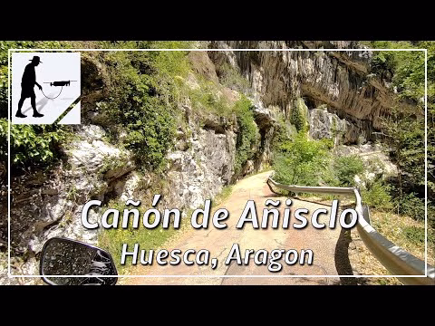
The river Bellos (sometimes called Añisclo) flows in a southerly direction and has cut an impressive gorge into the rock over time. The navigable part of the Cañón de Añisclo gorge is about 11 km long. The southern end of the gorge begins about 3 km northwest of the village of Escalona. The northern end is marked by the former hermitage Ermita de San Úrbez. From here, the road then winds up the mountain in a few switchbacks and leaves the gorge. The road continues north to the village of Fanlo and south to the village of Buerba. Inside the gorge, the road is narrow and winding. The road surface is in poor condition and there are several unlit tunnels. The side of the river is changed several times over smaller bridges. Nevertheless, the road is easy to drive on with due caution, as the main part of the route is designated as a one-way road in the south-north direction. However, rockfall must be expected in some places. The road is located in the province of Huesca, in the region of Aragon.
▬ Content ▬▬▬▬▬▬▬▬▬▬▬▬▬▬▬▬
00:00 Intro
00:15 Prolog
01:24 The Ride
20:24 Outro
▬ Links ▬▬▬▬▬▬▬▬▬▬▬▬▬▬▬▬▬
Playlist Spain: https://www.youtube.com/playlist?list=PLTYKWgwieoeLHSTGj8b7mdAIqrosKg_T-
Playlist Gorges: https://www.youtube.com/playlist?list=PLTYKWgwieoeJHap1bKTsn_Pcjo8_V89rP
WalkTheMavic: https://www.youtube.com/channel/UCVKby-_mUxgoSbw19i30v6Q
▬ About this channel ▬▬▬▬▬▬▬▬▬▬▬▬
Walk The Mavic (WTM) – Interesting roads, passes and gorges in the Alps – Nature and landscapes – Castles, forts, fortresses and fortifications – Photos and videos, if possible and allowed, also aerial photos/videos with the drone.